
Her Fearful Symmetry: Hurricane Voyeurism
- Sep 8, 2017
- 5 min read
"There is really no such thing as bad weather, only different kinds of good weather."
-John Ruskin

There she is. Irma (Old German for War Goddess). All devastation, destruction, displacement, death, and other d-words considered, I will admit that she is absolutely gorgeous. Not only is she gorgeous, but she has been the object of my gaze for over 48 hours. The above image (photographed by the weather satellite GOES-16) captures her magnificently. But what exactly is a hurricane?
First, there must be warm, moist air (ocean waters near the equator--water temperature at ~85 degrees). This warm, moist air rises, causing low pressure at the surface. Because of that low pressure, more air comes to take that place, and it rises too (higher pressure up above). When all this moist air rises, it cools and forms clouds. But since all this warm, moist air (remember, this doesn't happen over dry land because there isn't as much water) is rising, the clouds start to move and swirl to make more room for the formation of more clouds. This then becomes a "system" and more swirling clouds form and naturally, an eye is formed and it can be very defined or it can be kind of sloppy. The pressure is low in the eye and it is clear and calm in the eye. The movement of those swirling clouds is fast and destructive and once it reaches 74 mph, it is considered a hurricane.
What does the word hurricane mean? It derives from the Mayan god Hurakan (Spanish Huracan)--God of the Storm, or Heart of Sky.
I will also admit, I was fascinated by the many appropriate anagrams for "Hurricane"
Raunchier
Churner
Air
Racer
Run
Crier
Ruin
Rune
Her
Ache
Rain
Hernia
Urchin
Rare
Chary
Auric

In 1992, I was six years old when Hurricane Andrew pummeled the Bahamas, Florida, and Louisiana. My grandmother, who lived in Florida all my life, gave me a book about Hurricane Andrew that showed the destruction, homeless people, and bewildered animals in its pages. And there it was, the birth of my fascination for natural disasters and weather.
Irma. She. Her. There is a lot of consternation regarding the naming and personification of tropical storms and hurricanes. Some people think that it's a commercial trend to make profit in one way or another. Others believe that it's a way of creating hype. However, it has proven beneficial to name such storms that are long-lasting (unlike other disasters like tornadoes, volcanos, mudslides, and tsunamis) because it helps to differentiate between multiple storms going on at once, much like what is happening now. And I can't help but think of her as a woman. She's broad, curvy, and has impeccable symmetry for a storm. At her peak, she had a clear, wide eye, creamy spiral bands, and continues to be bountiful and proportionate. And don't forget the very distinct spiral rain bands that liken her to a saw blade slicing her way through the sea.

I want to call her beautiful. For fun, I Googled "Beautiful Hurricane Irma" but never was the descriptor applied to Irma herself. But she has been described in many other ways:
Ways In Which Irma Has Been Described
Angry
Beast
Calculating
Damaging
Dangerous
Deadly
Deadly monster
Devastating
Destructive
Epic
Extreme
Furious
Giant
Historic
Horrendous
Horrible
Horror movie
Howling
Incredible
Just amazing
Large
Life-threatening
Magnificent
Major
Monstrous
Mother Nature's Rage & Wrath (according to Jennifer Lawrence)
Not good
Not Pretty
Nuclear
Out of this world
Powerful
Practically impossible
Quick
Rapid
Scary
Sickening
Steady
Strong
Stupid
Symmetrical
Terrible
Terrifying
Traumatic
Ugly
Unbelievable
Unimaginable
Unstoppable
Westward
Windswept
But I have yet to hear the word "Tempest" (from Latin's tempestas meaning 'season, weather, storm'). It's the word that forms in my mind when I see images of her.

Another image taken by GOES-16.

Image taken by the International Space Station
Thanks to satellite imagery, we have amazing flat-earth defying images of Earth and her meteorological goings-on. These most recent satellites--of the Geostationary Operational Environmental Satellite (GOES) variety--are stationed over 22,000 miles above Earth, tracking, documenting, and analyzing the western hemisphere. Three more satellites are due to orbit by the year 2024.
Satellites observe what is called the visible and infrared spectrums. The visible spectrum is what you see above. Infrared is the technology's ability to gauge temperatures, surface features, cloud types, and other features of various systems.

Humans love circles. Mesmerizing, hypnotizing, we are drawn to the spiral, the perfection. In a hurricane's case, there is a generative and degenerative process of that circle and it is adorably diagrammed in the Dvorak Technique, a system that breaks down the patterns of formation and deformation of cyclones.

Weather, of course, is older than our idea of science and it has been the scientists' jobs to turn intangibles into tangibles. Storms are made of just a several elements and light, which allows us to finally see it. But how do you describe the wind other than by what it moves? Edmond Halley drew the first "thematic map" (a map that represents certain identifying aspects of a certain place) that depicted meteorological aspects (the wind).
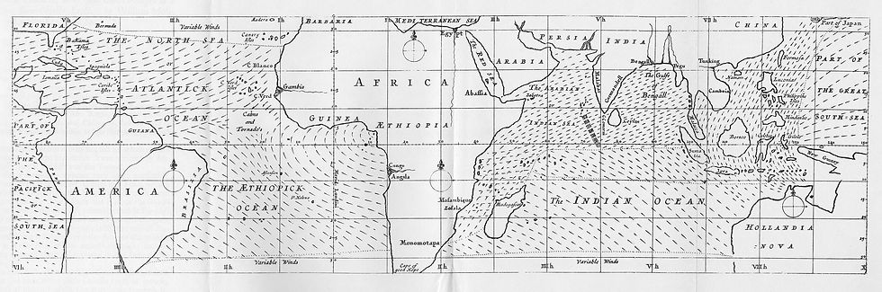
To help the conception of the reader, in a matter of so much difficulty, I believed it necessary to adjoyn a scheme, showing at one view all the various Tracts and Courses of these Winds; whereby 'tis possible the thing may be better understood, than by any verbal description whatsoever. -Edmond Halley
Lewis Fry Richardson imagined a large theater that represented the surfaces of the Earth. A pillar rose in the center of the theater and contained voyeurs, analysts, etc. At the top of the pillar was a pulpit where the leader stayed, in charge of the massive theater.

I love looking at weather maps. Their curves, lines, and swirls make the intangible tangible.
Until it is tangible.
There is yet another way that we are voyeurs of the storm. First, she is an image on a map. A future threat, a swirl of water and wind out near Africa. It approaches, near and nearer. Then comes the calm, as they call it, that gorgeous day of sunbathers and Instagram pictures just days before she arrives. Then come the clouds seen from land and plane. Fun fact: In 1943, Joseph P. Duckworth was the first pilot to purposely fly into the eye of a hurricane. Then comes the wind, moving everything. Surf's up for some people at the beach. Some businesses are boasting that they're still open despite the mass destruction heading their way. Store owners stand with their arms tight across their chest, defending why they're still there to the journalist, the wind blowing at their shirts, their "Come In, We're Open" sign swinging on the glass door. Next comes the rain, more wind. Then more wind and then wind. Just wind and storm surge. Sustained winds. A tornado without a curfew. And as big or bigger than the whole state. And then the destruction. The people and animals emerging from it all as if walking out of caves. Left with not much more than what a Neanderthal can claim as his own.
As I type this, Irma is making landfall in Cuba.
What's past is prologue.
-William Shakespeare, "The Tempest"
Comments